| Alaska has six times as many pilots and 16
times as many aircraft per capita
as the rest of the nation. Lake Hood, in Anchorage, is the world’s busiest
seaplane base. It averages 800 takeoffs and landings on a peak
day. There are approximately 90,000 landings and takeoffs during the late spring, summer and early autumn months when Lake Hood
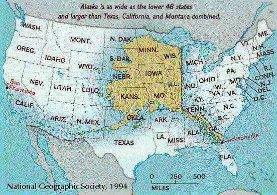
is not frozen. Currently, the population in Alaska stands at more than 735,000 people and counting. Many people move here for the experience, while others want a new and exciting adventure. Still some move to escape the hustle and bustle of life elsewhere. At 656,425 square miles, Alaska is the largest state, twice the size of Texas, and one fifth the size of the entire United States. 570,374 square miles of Alaska are land areas and 86,051 square miles of Alaska are covered by water. North to South, Alaska is 1,400 miles long. East to West, it is 2,700 miles wide. Alaska has the longest general coastline of any state. The Alaskan coastline extends for 6,640 miles, a distance greater than that of all the other states' coastlines combined. Including islands, Alaska has 33,904 miles of shoreline. The estimated tidal shoreline, including islands, inlets sounds and bays, is 47,300 miles. Alaska is one of the most beautiful states with incredible landscapes and a variety of wildlife. There are more than three million lakes in Alaska larger than 20 acres in size. Lake Illiamna in Southwest Alaska is the second largest fresh water lake in the U.S. Alaska has more inland water than any other state--20,171 square miles. Inland water covers an area in Alaska larger than the area of Vermont and New Hampshire combined. The Yukon River (third longest in the nation) flows 1400 miles through central Alaska and into the Bering Sea. The river begins in Canada and is a total of 2300 miles long. Alaska has an estimated 100,000 glaciers which cover almost five percent (over 25,000 square miles) of the state. There are more active glaciers in Alaska than in the rest of the inhabited world. Malaspina Glacier is the largest glacier in the state, with an area of 1,500 square miles. It extends 50 miles from Mount St. Elias toward the Gulf of Alaska. This glacier covers more land area than the State of Rhode Island. Alaska contains over 100 volcanos and volcanic fields which have been active within the last one and a half million years. Over 40 of these have been active in historic time. These make up about 80% of all active volcanos in the United States and 8% of all active above-water volcanos on earth. Alaska has 80 percent of all the active volcanos in the U.S. The 1912 Katmai eruption, which formed the Valley of Ten Thousand Smokes on the Alaska Peninsula, was the largest 20th century eruption on earth. Alaska has 39 mountain ranges, containing 17 of the 20 highest peaks in the United States. Denali (Mt. McKinley) is the highest mountain in North America at 20,320 feet. The Brooks Range, paralleling 68 degrees north latitude, extends over 700 miles across the entire width of Alaska from the Bering Sea on the west coast of Alaska easterly to the Beaufort Sea in Canada. It covers approximately 110,000 square miles, is largely unexplored and is the biggest mountain range in the world situated entirely north of the Arctic Circle. Alaska's climate is variable, due to the state's large size. The southeastern and south central coasts are wet and mild, the interior is cool and dry, and the northern region experiences very cold, dry weather. The record high temperature in Alaska was 100 degrees Fahrenheit at Fort Yukon in 1915. The record low temperature was -80 degrees Fahrenheit at Prospect Creek Camp in 1971. The North Slope of Alaska is a region found in the northern most part of the state. It is bordered by the foothills of the Brooks Range to the south and the Arctic Ocean to the North. The region covers 89,000 square miles, lies entirely north of the Arctic Circle and is about the size of Minnesota. Depending on how you look at it, Alaska has both the easternmost and westernmost points in the United States. The 180th meridian, the dividing line between east and west longitudes, passes through Alaska. According to one view, the westernmost point is Amatignak Island, 179'10' west; and the easternmost, Pochnoi Point, 179'46' east. On the other hand, if you are facing north, east is to your right and west to your left. Therefore, the westernmost point is Cape Wrangell, Attu Island, 172'27' east; and the easternmost is near Camp Point, in southeastern Alaska, 129'59' east. |

